
← Previous Photo | Next Photo → |
University of Nevada, Reno Map
Date of photo: February 1988
Photographer: Mark Brethauer
Source: Historic American Buildings Survey (Library of Congress)

Description
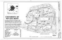
A map of the University of Nevada, Reno. Drawn in February 1988, it shows all the buildings that were on campus at the time. Many buildings are marked with the year of construction.
Actions
⇓ Download This Photo
⇓ Embed This Photo
Other Data
Date Uploaded: April 19, 2024
Permanent Link: http://wnhpc.com/details/habsnv0102
Source: Historic American Buildings Survey (Library of Congress)
Source URL: https://www.loc.gov/item/nv0102/
Source Caption: University of Nevada (Site Plan), Evans, Virginia & Ninth Street, Reno, Washoe County, NV Drawings from Survey HABS NV-18
Post A Comment