Sunday, September 27, 2009
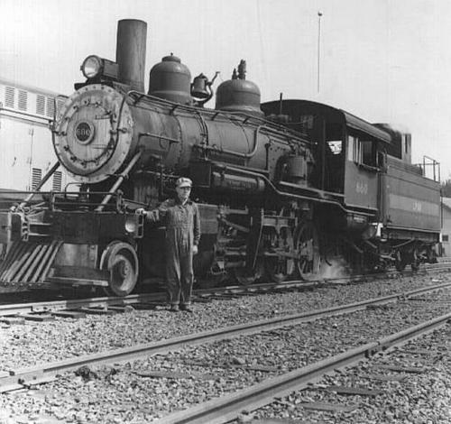
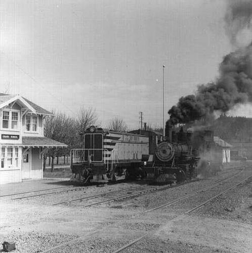
I found these photos at the Willamina & Grand Ronde Railway history page. They show the rail yards in Grand Ronde, Oregon, and one steam engine in particular. Now you may be wondering why these photos from Oregon are in the Nevada historic photo collection. The connection lies in the locomotive itself.
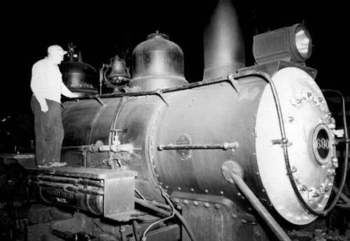
These photos were taken in 1960. The locomotive is #680, which had served on this logging railroad for 40 years, and was being kept active as a backup engine if the diesel locomotive was ever unavailable. Later on the engine was retired completely and parked in the enginehouse nearby.
In 1977 a fellow from Nevada was looking to purchase a working steam engine, and he found his way to Grand Ronde. A selling price was agreed on, and the engine was hauled out of the shop and loaded onto a truck. Over the next few days it was driven down to Nevada.
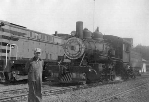
The man’s name was Bob Gray, and the railroad he owned was the Virginia & Truckee Railroad. He acquired this engine, #680, and renumbered it V&T #29. This is the same Engine #29 that still runs in Virginia City today. It’s been kept in excellent condition, and I have many present-day pictures of it in service on the Comstock. But I wasn’t sure if there were any photos of it in its former life to be found. That’s why finding these photos are so great.
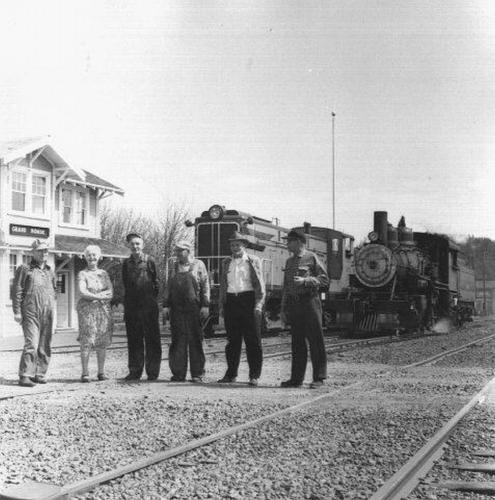
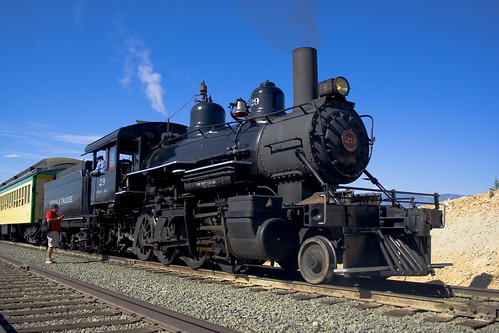
Photos are from the Salem Public Library Historic Photograph Collections, Salem Public Library, Salem, Oregon (exccpt for the color one, which is mine), and published online by Brian McCamish at http://www.brian894x4.com/WillaminaGrandRondeRR.html.
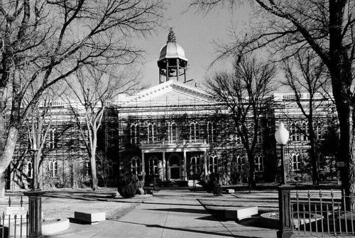
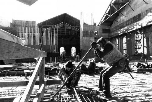
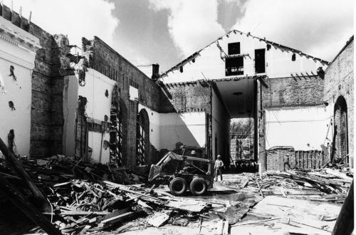
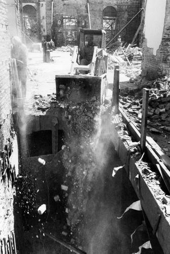
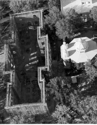
No Safe Place, in his Old Nevada feed (and on Flickr), has been putting up pictures from the Nevada State Capitol Building and the reconstruction that took place in the 1970s. The building was completely gutted, the rebuilt with modern materials and to modern earthquake standards. These pictures are pretty fascinating. A few of them are shown here, but there are more than 20 in all.
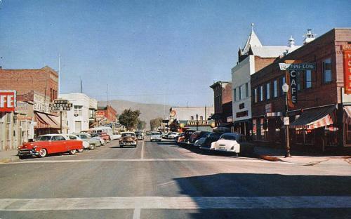
A drive through downtown Carson City, in postcards.
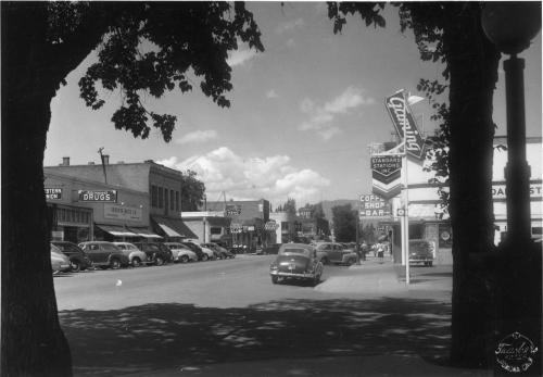
We start at Musser Street. First we can stop by Sprouse-Reitz for a little shopping.
Then we find ourselves at Proctor. In color, even! A grocery store is on the left; let’s stop and pick up some Postum.
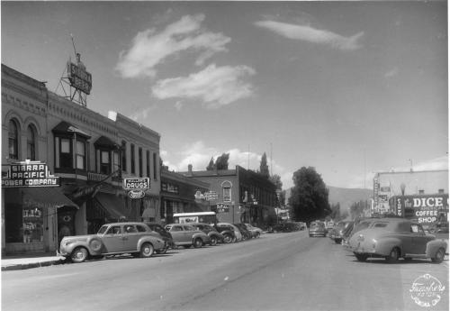
Next comes Telegraph. It’s getting hot, so we should stop by the Ship Bar to quench our thirst.
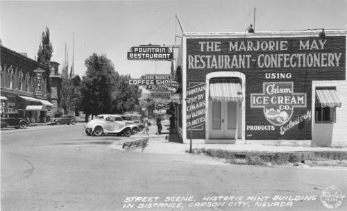
And soon we reach Spear. Suddenly I’m hungry for some Chism ice cream.
And finally we’re at Caroline, and leaving downtown. The train station is on the right. Should we hop on the banana train, or keep going?
I’ve been adding so many new photos lately, and not posting any of them here. I feel like I’m letting myself down. But even though I love looking through these photos, it seems like such a chore to add them, describe them, tag them. I have what seems like thousands of photos still in the queue to add, and I get faint just thinking about it.
But I plowed through in the last couple of weeks and made some big additions. So I should start highlighting some of the photos now. First up, Carson City’s Chinatown. Chinatown was located along Third Street, just east of Stewart. It started in the 1870s, when the Chinese came to the area to build the railroad, and lasted until the 1950s, when the last of the buildings burned down or were demolished. Most of the photos were from the 1930s and 40s, when it was almost a ghost town. Here are some good ones, including “Yee Bong Cafe”, a chop suey house.


Saturday, December 20, 2008
Google a little while ago posted a bunch of the old LIFE Magazine photo archive. I did searches for Northern Nevada, and didn’t turn up a whole lot. Here’s a taste of what I did find, though.
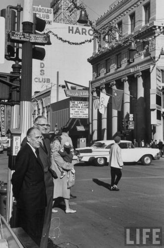
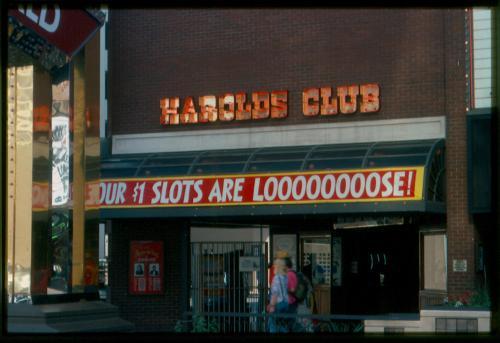
Gaming mogul Bill Harrah in downtown Reno in 1959. In the background is Harold’s Club, which closed in the 90s and was torn down, Harrah’s Club, which expanded to take up the whole block, and the First National Bank of Nevada, which still stands on the corner, but is also part of Harrah’s. Planet Hollywood was there for a long time, but now it’s Ichiban steak house and sushi bar.
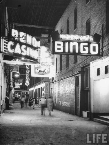
This from 1945 shows Douglas Alley, looking from Virginia Street to Center. Lots of great signs here.
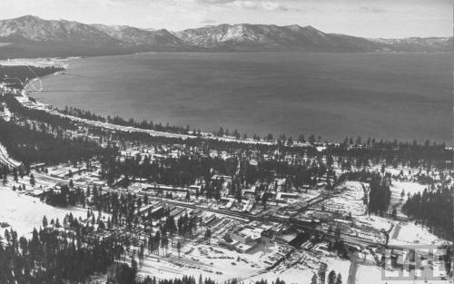
This aerial photo of Lake Tahoe was also from 1959, and must have been part of a feature story on Bill Harrah. In the foreground is Harrah’s casino at Stateline, which now has grown into a huge hotel-casino complex.
Saturday, November 8, 2008
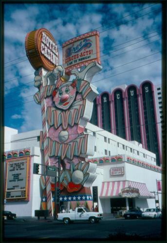
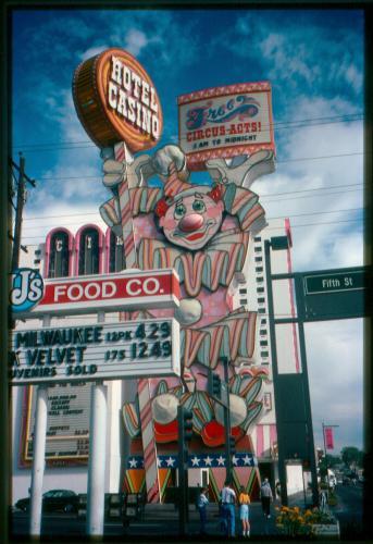
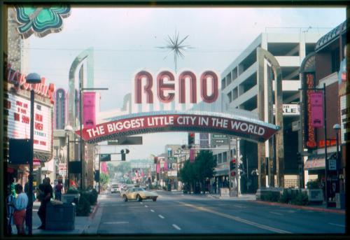
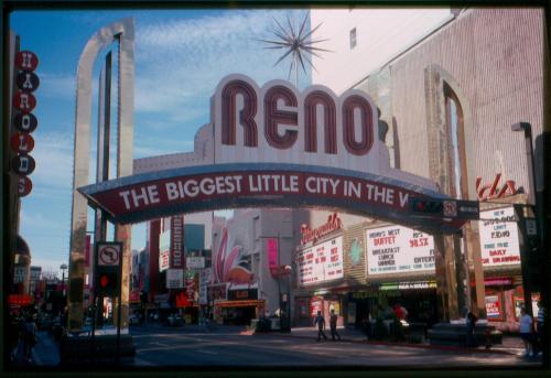
1993 was the year I started going to UNR in Reno, so what a coincidence to find these photos on Flickr of downtown Reno in that exact year. Jose P Isern Comas put them up on his photostream, apparently photos that he himself took of the downtown casinos. I only wish there were more, especially of the supermarket that used to be on the site that Silver Legacy now sits. All we get is the sign for the market in one of the shots. But the Harold’s Club can also be seen in a couple of these, which was torn down in 1999. As well as the pink paint on the Circus Circus, which was wisely ditched around the same time.

Saturday, October 25, 2008

This view from high above Carson City shows most of downtown, with the Capitol Building at the center. There’s much about this photo that has changed in the 40-50 years since it was taken. To the south (right) of the Capitol, the whole Capitol Plaza and Legislature Building have not been constructed yet. Instead there is still a sprawl of scattered houses and commercial buildings, along with the Nye state office building. The brick buildings right across 2nd Street from the Capitol date back to the 1860s, when Carson City was just a few years old.
To the north of the Capitol, you can still see the Senator Cafe standing at the corner of Carson and Musser.
Looking out to the east of town, the last street is Harbin Ave, and beyond that is nothing but empty pasture. Also notice how none of the streets, like Roop and Stewart, go all the way north to connect with William Street (Hwy 50). That’s because that empty area used to be the V&T Railroad yards. The tracks were torn up, but the land hadn’t started to be developed yet.
This was a simpler time for Carson City, but also this shows Carson right at the precipice of the explosive growth that occurred in the mid 20th century. In about 20 years time, Carson City went from a small town clustered around the Capitol to a sprawling town that filled up the Eagle Valley in every direction. In this photo we were right at the edge.
Wednesday, October 22, 2008
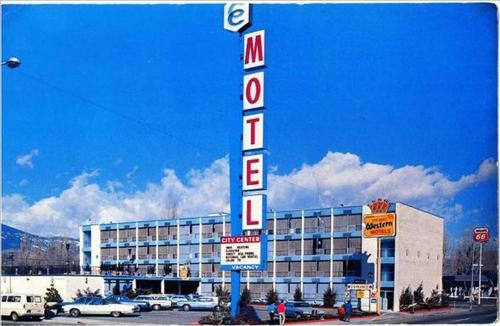
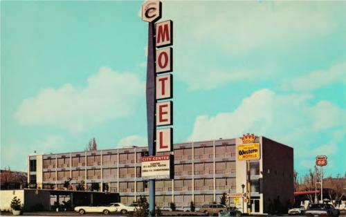
The City Center Motel at the northwest corner of Carson and Washington is seen in what appears to be the 1970s, judging by the cars. The Best Western crown stands proudly by the motel, but it is overshadowed by the motel’s own sign, reaching high into the sky.
Wednesday, October 22, 2008
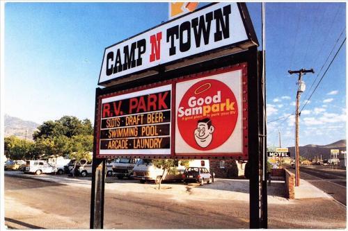
The Camp N Town RV Park sits right on North Carson Street, near the intersection with Hot Springs Road. It’s a “Good Sampark” and “A good place to park your RV.” They offer a swimming pool, arcade, laundry, and of course, liquor and gambling.
This sign still stands at the north end of town, but what is most notable about this photo are the things that are almost not in it. Look at the far right to see signs for some of the other North Carson businesses that no longer exist. The 49er Motel. The Scolari’s supermarket, and the Thrifty Drug.
Wednesday, October 22, 2008

This postcard looks down on Carson City from great height during the 1990s. The view is to the southwest, and the town can be seen butting right up to the bottom of C Hill.
Since this photo is so recent, not much has changed since it was taken. But even at this altitude, there are a few notable things that can bracket the date of the photo. For one, the old V&T Enginehouse is not there. The large dirt scar just below and to the right of center marks the site where the “Old Stone Fort” sat for nearly 120 years, until its demolition in 1991.
A few other details can be seen that place the photo squarely in the 90s. The Penguin Drive-In, at the corner of Carson and Sophia, is still standing. That old-time burger stand was torn down around the turn of the millenium. A few blocks away, Caroline Street still runs next to the Nevada State Museum. That stretch of road was abandoned in 1999 to make way for a public plaza north of the museum. And way down at the south end of town, the Target (opened 2000) and Super Wal*Mart (opened 2002) are nowhere to be found.
The astute among you can find many other changes in the ten years or so since this photo was taken, I’m sure.